
Haz una donación
Mapa topográfico Town of Rensselaerville
Haga clic en el mapa para ver la altitud.
Haz una donación
Acerca de este mapa
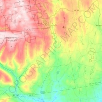
Nombre: Mapa topográfico Town of Rensselaerville, altitud, relieve.
Altitud media: 413 m
Altitud mínima: 190 m
Altitud máxima: 657 m
Haz una donación
Otros mapas topográficos
Haga clic en un mapa para ver su topografía, su altitud y su relieve.
Preston Hollow
United States > New York > Albany County > Town of Rensselaerville
Altitud media: 372 m
Haz una donación
Haz una donación
Haz una donación
Albany Pine Bush Preserve
United States > New York > Albany County > City of Albany
Altitud media: 85 m
Haz una donación
Albany
United States > New York > Albany County > Albany
The highest natural point in Albany is a USGS benchmark near the Loudonville Reservoir off Birch Hill Road, at 378 feet (115 m) above sea level. The lowest point is sea level at the Hudson River (the average water elevation is 2 feet (0.61 m)), which is still technically an estuary at Albany and is affected by…
Altitud media: 114 m