
Haz una donación
Mapa topográfico San Fernando Valley
Haga clic en el mapa para ver la altitud.
Haz una donación
Acerca de este mapa
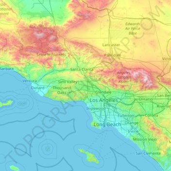
Nombre: Mapa topográfico San Fernando Valley, altitud, relieve.
Altitud media: 496 m
Altitud mínima: 0 m
Altitud máxima: 2.998 m
Haz una donación
Otros mapas topográficos
Haga clic en un mapa para ver su topografía, su altitud y su relieve.
Valley Village Neighborhood Council District
United States > California > Los Angeles County > Los Angeles
Altitud media: 199 m
Studio City Neighborhood Council District
United States > California > Los Angeles County > Los Angeles
Altitud media: 255 m
Canoga Park Neighborhood Council District
United States > California > Los Angeles County > Los Angeles
Altitud media: 255 m
Haz una donación
Porter Ranch Neighborhood Council District
United States > California > Los Angeles County > Los Angeles
Altitud media: 460 m
Van Nuys Neighborhood Council District
United States > California > Los Angeles County > Los Angeles
Altitud media: 224 m
Haz una donación
Winnetka Neighborhood Council District
United States > California > Los Angeles County > Los Angeles
Altitud media: 244 m
Sherman Oaks Neighborhood Council District
United States > California > Los Angeles County > Los Angeles
Altitud media: 257 m
Chatsworth Neighborhood Council District
United States > California > Los Angeles County > Los Angeles
Altitud media: 360 m
North Hollywood Neighborhood Council District
United States > California > Los Angeles County > Los Angeles
Altitud media: 196 m
Haz una donación
Encino Neighborhood Council District
United States > California > Los Angeles County > Los Angeles
Altitud media: 288 m
Pacoima Neighborhood Council
United States > California > Los Angeles County > Los Angeles
Altitud media: 312 m
Pacific Palisades
United States > California > Los Angeles County > Los Angeles
Pacific Palisades was formally founded in 1921 by a Methodist organization, and in the years that followed became a refuge for Jewish artists and intellectuals fleeing the Holocaust. The Palisades would later be sought after by celebrities and other high-profile individuals seeking privacy. It is known for its…
Altitud media: 196 m
Haz una donación
Sherman Oaks Neighborhood Council District
United States > California > Los Angeles County > Los Angeles
Altitud media: 257 m
Haz una donación
Will Rogers State Historic Park
United States > California > Los Angeles County > Los Angeles
Altitud media: 152 m
Valley Village Neighborhood Council District
United States > California > Los Angeles County > Los Angeles
Altitud media: 199 m
Haz una donación
Chatsworth Neighborhood Council District
United States > California > Los Angeles County > Los Angeles
Altitud media: 360 m
Chatsworth Neighborhood Council District
United States > California > Los Angeles County > Los Angeles
Altitud media: 361 m
Haz una donación
Van Nuys Neighborhood Council District
United States > California > Los Angeles County > Los Angeles
Altitud media: 224 m
Chatsworth Neighborhood Council District
United States > California > Los Angeles County > Los Angeles
Altitud media: 360 m
Haz una donación
Los Angeles City Council District 11
United States > California > Los Angeles County > Los Angeles
Altitud media: 141 m
North Hollywood Neighborhood Council District
United States > California > Los Angeles County > Los Angeles
Altitud media: 196 m
Haz una donación
Chatsworth Neighborhood Council District
United States > California > Los Angeles County > Los Angeles
Altitud media: 360 m
Haz una donación
Los Angeles City Council District 7
United States > California > Los Angeles County > Los Angeles
Altitud media: 512 m
Haz una donación
Rio de Los Angeles State Park State Recreational Area
United States > California > Los Angeles County > Los Angeles
Altitud media: 141 m