
Haz una donación
Mapa topográfico Jarvis
Haga clic en el mapa para ver la altitud.
Haz una donación
Acerca de este mapa
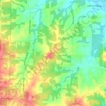
Nombre: Mapa topográfico Jarvis, altitud, relieve.
Lugar: Jarvis, Jefferson County, Missouri, 63065, United States (38.24811 -90.51429 38.28811 -90.47429)
Altitud media: 169 m
Altitud mínima: 131 m
Altitud máxima: 217 m
Haz una donación
Otros mapas topográficos
Haga clic en un mapa para ver su topografía, su altitud y su relieve.
Haz una donación
Big River
United States > Missouri > Jefferson County > Cedar Hill
The Big River is a tributary of the Meramec River in east-central Missouri. The river rises in western Iron County near the summit of Johnson Mountain just north of Missouri Route 32 and approximately 3.5 miles southeast of the community of Enough. It flows through Washington, Saint Francois, and Jefferson…
Altitud media: 220 m
Haz una donación
Haz una donación
Myron and Sonya Glassberg Conservation Area
United States > Missouri > Jefferson County
Altitud media: 171 m