
Mapa topográfico Trasching
Haga clic en el mapa para ver la altitud.
Acerca de este mapa
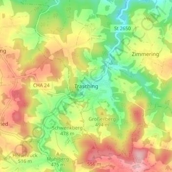
Nombre: Mapa topográfico Trasching, altitud, relieve.
Lugar: Trasching, Roding, Landkreis Cham, Bayern, Deutschland (49.13559 12.44075 49.17559 12.48075)
Altitud media: 463 m
Altitud mínima: 364 m
Altitud máxima: 574 m
Otros mapas topográficos
Haga clic en un mapa para ver su topografía, su altitud y su relieve.
Burgruine Schwärzenburg
Deutschland > Bayern > Landkreis Cham > Roding > Strahlfeld
Die Höhenburg wurde vermutlich im 13. Jahrhundert auf dem Grund des Bamberger Bischofs von den Herren von Fronau (Adelsgeschlecht), die schon Anfang des 12. Jahrhunderts urkundlich genannt wurden, erbaut. Eine Vorgängeranlage der Höhenburg könnte die Turmhügelburg Haselberg auf dem Gebiet des Haselbergs…
Altitud media: 455 m