
Mapa topográfico Braughing
Haga clic en el mapa para ver la altitud.
Acerca de este mapa
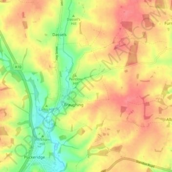
Nombre: Mapa topográfico Braughing, altitud, relieve.
Altitud media: 104 m
Altitud mínima: 63 m
Altitud máxima: 134 m
Otros mapas topográficos
Haga clic en un mapa para ver su topografía, su altitud y su relieve.
Spellbrook
United Kingdom > England > Hertfordshire > East Hertfordshire > Sawbridgeworth
Altitud media: 71 m
Astonbury Wood
United Kingdom > England > Hertfordshire > East Hertfordshire > Aston
Altitud media: 83 m
Waterford
United Kingdom > England > Hertfordshire > East Hertfordshire > Waterford
Altitud media: 66 m
Throcking
United Kingdom > England > Hertfordshire > East Hertfordshire > Buntingford
Altitud media: 126 m
Tewin Wood
United Kingdom > England > Hertfordshire > East Hertfordshire > Burnham Green
Altitud media: 101 m
Chapmore End
United Kingdom > England > Hertfordshire > East Hertfordshire > Tonwell
Altitud media: 65 m
Stanstead St Margarets
United Kingdom > England > Hertfordshire > East Hertfordshire
Altitud media: 48 m
Hadham Cross
United Kingdom > England > Hertfordshire > East Hertfordshire > Much Hadham
Altitud media: 79 m
Thorley Street
United Kingdom > England > Hertfordshire > East Hertfordshire > Thorley
Altitud media: 74 m
Whempstead
United Kingdom > England > Hertfordshire > East Hertfordshire > Dane End
Altitud media: 95 m
Church End
United Kingdom > England > Hertfordshire > East Hertfordshire > Little Hadham
Altitud media: 95 m
Crab's Green
United Kingdom > England > Hertfordshire > East Hertfordshire > Stocking Pelham
Altitud media: 111 m
Baker's End
United Kingdom > England > Hertfordshire > East Hertfordshire > Wareside > Baker's End
Altitud media: 73 m
Hare Street
United Kingdom > England > Hertfordshire > East Hertfordshire > Great Hormead
Altitud media: 110 m
Hertford Heath Nature Reserve
United Kingdom > England > Hertfordshire > East Hertfordshire > Hertford Heath
Altitud media: 79 m
Moor Green
United Kingdom > England > Hertfordshire > East Hertfordshire > Ardeley
Altitud media: 123 m
Painter's Green
United Kingdom > England > Hertfordshire > East Hertfordshire > Datchworth
Altitud media: 100 m
Tewin Wood
United Kingdom > England > Hertfordshire > East Hertfordshire > Burnham Green
Altitud media: 101 m
Broad Green
United Kingdom > England > Hertfordshire > East Hertfordshire > Bayford
Altitud media: 73 m
Hertford Lock No 1
United Kingdom > England > Hertfordshire > East Hertfordshire > Hertford
Altitud media: 53 m