
Gracias por apoyar a este sitio ❤️
Haz una donación
Haz una donación
Mapa topográfico Wilson Reservoir
Haga clic en el mapa para ver la altitud.
Gracias por apoyar a este sitio ❤️
Haz una donación
Haz una donación
Wilson Reservoir
Wilson Lake is located at 38°56′25″N 98°33′24″W / 38.94028°N 98.55667°W / 38.94028; -98.55667 (38.9401464, -98.5567638) at an elevation of 1,516 feet (462 m). It lies in north-central Kansas in the Smoky Hills region of the Great Plains. Most of Wilson Lake lies in Russell County with a small portion of its southeastern arm extending into Lincoln County.
Gracias por apoyar a este sitio ❤️
Haz una donación
Haz una donación
Acerca de este mapa
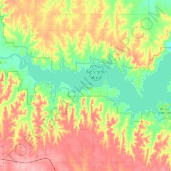
Nombre: Mapa topográfico Wilson Reservoir, altitud, relieve.
Lugar: Wilson Reservoir, Russell County, Kansas, United States (38.90773 -98.67043 38.96942 -98.47646)
Altitud media: 508 m
Altitud mínima: 449 m
Altitud máxima: 574 m
Gracias por apoyar a este sitio ❤️
Haz una donación
Haz una donación