
Mapa topográfico Ochsenfurt
Mapa interactivo
Haga clic en el mapa para ver la altitud.
Acerca de este mapa
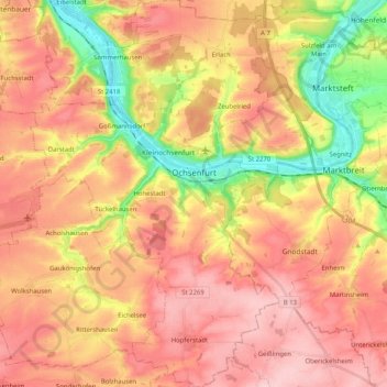
Nombre: Mapa topográfico Ochsenfurt, altitud, relieve.
Lugar: Ochsenfurt, Landkreis Würzburg, Bavaria, 97199, Germany (49.59250 9.97846 49.72492 10.11459)
Altitud media: 271 m
Altitud mínima: 173 m
Altitud máxima: 339 m
Otros mapas topográficos
Haga clic en un mapa para ver su topografía, su altitud y su relieve.
Obereisenheim
Germany > Bavaria > Landkreis Würzburg
Obereisenheim, Eisenheim, Estenfeld (VGem), Landkreis Würzburg, Bavaria, 97247, Germany
Altitud media: 245 m
Kist
Germany > Bavaria > Landkreis Würzburg
Kist, Verwaltungsgemeinschaft Kist, Landkreis Würzburg, Bavaria, 97270, Germany
Altitud media: 346 m