
Haz una donación
Mapa topográfico Dinuba
Haga clic en el mapa para ver la altitud.
Haz una donación
Dinuba
According to the United States Census Bureau, the city has a total area of 6.5 square miles (17 km2), all of it land. The general topography is quite level ground, at an elevation of approximately 345 feet (105 m) above mean sea datum. The gradient is approximately ten feet per mile, from east-northeast to west-southwest. Groundwater generally also flows with the surface of the terrain; that is, from the northeast to the southwest. There are small hills to the northeast side of Dinuba with some elevations achieving heights of 526 feet (160 m).
Haz una donación
Acerca de este mapa
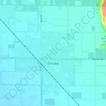
Nombre: Mapa topográfico Dinuba, altitud, relieve.
Lugar: Dinuba, Tulare County, California, 93618, United States (36.52633 -119.43962 36.57128 -119.36773)
Altitud media: 107 m
Altitud mínima: 97 m
Altitud máxima: 220 m
Haz una donación
Otros mapas topográficos
Haga clic en un mapa para ver su topografía, su altitud y su relieve.
Mount Whitney
United States > California > Tulare County
Mount Whitney (Paiute: Tumanguya; Too-man-i-goo-yah) is the highest mountain in the contiguous United States and the Sierra Nevada, with an elevation of 14,505 feet (4,421 m). It is in East–Central California, on the boundary between California's Inyo and Tulare counties, 84.6 miles (136.2 km) west-northwest…
Altitud media: 3.903 m
Haz una donación
Haz una donación
Haz una donación
Haz una donación
Haz una donación
Haz una donación
Haz una donación
Haz una donación
Mount Whitney
United States > California > Tulare County
Mount Whitney (Paiute: Too-man-i-goo-yah or Too-man-go-yah) is the highest mountain in the contiguous United States, with an elevation of 14,505 feet (4,421 m). It is in East–Central California, in the Sierra Nevada, on the boundary between California's Inyo and Tulare counties, and 84.6 miles (136.2 km)…
Altitud media: 3.903 m
Haz una donación
Haz una donación
Mount Whitney
United States > California > Tulare County
Mount Whitney (Paiute: Tumanguya; Too-man-i-goo-yah) is the highest mountain in the contiguous United States and the Sierra Nevada, with an elevation of 14,505 feet (4,421 m). It is in East–Central California, on the boundary between California's Inyo and Tulare counties, 84.6 miles (136.2 km) west-northwest…
Altitud media: 3.903 m
Allensworth
United States > California > Tulare County
Allensworth sits at an elevation of 213 feet (65 m), the same elevation as the huge and historically important Tulare Lake shore when it was full. The community is located in the ZIP Code 93219 and in the area code 661.
Altitud media: 63 m
Haz una donación
Poplar
United States > California > Tulare County > Poplar-Cotton Center > Poplar
Altitud media: 115 m
Haz una donación