
Haz una donación
Mapa topográfico Koshi River
Haga clic en el mapa para ver la altitud.
Haz una donación
Koshi River
The Kosi River catchment covers six geological and climatic belts varying in altitude from above 8,000 m (26,000 ft) to 95 m (312 ft) comprising the Tibetan plateau, the Himalayas, the Himalayan mid-hill belt, the Mahabharat Range, the Siwalik Hills and the Terai. The Dudh-Koshi sub-basin alone consists of 36 glaciers and 296 glacier lakes. The Kosi River basin borders the Tsangpo River basin in the north, the Mahananda River basin in the east, the Ganges Basin in the south and the Gandaki River basin in the west. The eight tributaries of the basin upstream the Chatra Gorge include from east to west.
Haz una donación
Acerca de este mapa
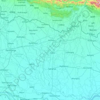
Nombre: Mapa topográfico Koshi River, altitud, relieve.
Lugar: Koshi River, Bihar, India (25.40557 86.43871 26.91017 87.25862)
Altitud media: 82 m
Altitud mínima: 25 m
Altitud máxima: 1.975 m
Haz una donación
Otros mapas topográficos
Haga clic en un mapa para ver su topografía, su altitud y su relieve.
Gaya
India > Bihar > Gaya Town C.D.Block
Gaya is connected to the rest of India by roads, rail and airways. The Grand Chord section of the Indian Railways passes through Gaya. Gaya Junction railway station railway station is a major junction station serving the city. Gaya Junction has been redeveloped as Model railway station recently and houses all…
Altitud media: 111 m
Haz una donación
Wazirganj
Wazirganj is a historical place from time of *Alha, Udal* This is the oldest temple of Khere Wali Maiya, where Alha and Udal had arrived. Wazirganj is located at 28°13′N 79°03′E / 28.22°N 79.05°E / 28.22; 79.05. It has an average elevation of 174 metres (570 feet).
Altitud media: 111 m
Haz una donación
Haz una donación
Haz una donación
Haz una donación
Haz una donación
Haz una donación
Jajuara
The climate is mainly dry and cool. In summer the temperature varies from 35 °C (95 °F) to 45 °C (113 °F). In winter it is typically 5 °C (41 °F) to 15 °C (59 °F). The elevation is 51m close to sea level. The soil is suited for agriculture, which is the main economic activity of the region.
Altitud media: 53 m
Siwan
Siwan city is located at coordinates 26°13′N 84°22′E / 26.22°N 84.36°E / 26.22; 84.36 Latitude and longitude. It is counted in one of the tarai region of Himalaya Mountain range. It has an average elevation of 72 metres (236 ft). Daha River, which is a small river, which floods in rainy season…
Altitud media: 64 m
Haz una donación
Haz una donación
Haz una donación
Haz una donación
Haz una donación
Haz una donación
Arrah
Arrah is located at the elevation of 192 m from the sea level at the bank of Son river, Ganga River and Gangi River. Arrah lies at the confluence of the Ganga and the Son River, other small rivers that flow in the town are Gangi River, Badki Nadi and Chhotki Nadi.
Altitud media: 59 m
Haz una donación
Haz una donación
Haz una donación