Geolocalizar

Mapa topográfico Blue Ridge Mountains

Mapa interactivo

Haga clic en el mapa para ver la altitud.

Acerca de este mapa

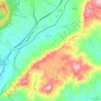
Nombre: Mapa topográfico Blue Ridge Mountains, altitud, relieve.

Lugar: Blue Ridge Mountains, Botetourt County, Virginia, United States (37.29428 -79.87675 37.37389 -79.77596)

Altitud media: 460 m

Altitud mínima: 290 m

Altitud máxima: 774 m

Although the term "Blue Ridge" is sometimes applied exclusively to the eastern edge or front range of the Appalachian Mountains, the geological definition of the Blue Ridge province extends westward to the Ridge and Valley area, encompassing the Great Smoky Mountains, the Great Balsams, the Roans, the Blacks, and other mountain ranges. To the east, two lower elevation ranges referred to as foothills are also often included as "spurs" of the Blue Ridge: the Brushy Mountains and the South Mountains.

Wikipedia (CC-BY-SA 3.0)

Otros mapas topográficos

Haga clic en un mapa para ver su topografía, su altitud y su relieve.

Fincastle

United States > Virginia > Botetourt County

Fincastle, Botetourt County, Virginia, 24090, United States

Altitud media: 363 m

Troutville

United States > Virginia > Botetourt County

Troutville, Botetourt County, Virginia, United States

Altitud media: 458 m

Eagle Rock

United States > Virginia > Botetourt County

Eagle Rock, Botetourt County, Virginia, 24085, United States

Altitud media: 379 m

Daleville

United States > Virginia > Botetourt County

Daleville, Botetourt County, Virginia, 24083, United States

Altitud media: 410 m

Cloverdale

United States > Virginia > Botetourt County

Cloverdale, Runaway Village, Botetourt County, Virginia, United States

Altitud media: 401 m

Oriskany

United States > Virginia > Botetourt County

Oriskany, Botetourt County, Virginia, 24130, United States

Altitud media: 404 m

Glen Wilton

United States > Virginia > Botetourt County

Glen Wilton, Botetourt County, Virginia, 24438, United States

Altitud media: 363 m

Coyner Mountain Overlook

United States > Virginia > Botetourt County

Coyner Mountain Overlook, Botetourt County, Virginia, 25012, United States

Altitud media: 381 m

Daleville

United States > Virginia > Botetourt County

Daleville, Botetourt County, Virginia, 24083, United States

Altitud media: 412 m

Haden

United States > Virginia > Botetourt County > Haden

Haden, Botetourt County, Virginia, 24438, United States

Altitud media: 339 m

Buchanan

United States > Virginia > Botetourt County

Buchanan, Botetourt County, Virginia, 24066, United States

Altitud media: 344 m

Laymantown

United States > Virginia > Botetourt County > Laymantown

Laymantown, Botetourt County, Virginia, United States

Altitud media: 412 m

Blue Ridge

United States > Virginia > Botetourt County

Blue Ridge, Botetourt County, Virginia, United States

Altitud media: 472 m