
Gracias por apoyar a este sitio ❤️
Haz una donación
Haz una donación
Mapa topográfico Spokane
Haga clic en el mapa para ver la altitud.
Gracias por apoyar a este sitio ❤️
Haz una donación
Haz una donación
Acerca de este mapa
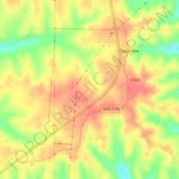
Nombre: Mapa topográfico Spokane, altitud, relieve.
Lugar: Spokane, Christian County, Missouri, United States (36.85146 -93.31583 36.87303 -93.29717)
Altitud media: 398 m
Altitud mínima: 361 m
Altitud máxima: 419 m
Gracias por apoyar a este sitio ❤️
Haz una donación
Haz una donación
Otros mapas topográficos
Haga clic en un mapa para ver su topografía, su altitud y su relieve.
Nixa
United States > Missouri > Christian County > Nixa
Nixa Public Schools operates four elementary schools for students in kindergarten through fourth grade: Helen-Matthews Elementary, Espy Elementary, Century Elementary, and the newest, High Pointe Elementary (named because it sits on the highest elevation in Christian County), opened in August 2007. Two…
Altitud media: 383 m
Gracias por apoyar a este sitio ❤️
Haz una donación
Haz una donación