
Haz una donación
Mapa topográfico Kadapa
Haga clic en el mapa para ver la altitud.
Haz una donación
Kadapa
Kadapa in the Rayalaseema region of Andhra Pradesh is located at 14°28′N 78°49′E / 14.47°N 78.82°E / 14.47; 78.82 about 250 km from Bangalore, 260 km from Chennai, 360 km from Vijayawada and 410 km from Hyderabad. The city is situated in the Bugga vanka or Ralla Vanka rivers bordered by the Palakondas to the south and to the east by a patch of hills casting north for the Lankamalas on Penna's other side. It has an average elevation of 138 metres (452 ft). Veligonda hills separates the districts of Nellore and Kadapa.
Haz una donación
Acerca de este mapa
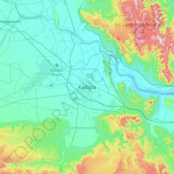
Nombre: Mapa topográfico Kadapa, altitud, relieve.
Lugar: Kadapa, YSR Kadapa, Andhra Pradesh, 516001, India (14.31529 78.66169 14.63529 78.98169)
Altitud media: 257 m
Altitud mínima: 102 m
Altitud máxima: 814 m
Haz una donación