
Haz una donación
Mapa topográfico Cocoa West
Haga clic en el mapa para ver la altitud.
Haz una donación
Acerca de este mapa
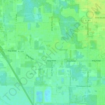
Nombre: Mapa topográfico Cocoa West, altitud, relieve.
Lugar: Cocoa West, Brevard County, Florida, United States (28.34540 -80.79467 28.37269 -80.74656)
Altitud media: 8 m
Altitud mínima: 1 m
Altitud máxima: 16 m
Haz una donación
Otros mapas topográficos
Haga clic en un mapa para ver su topografía, su altitud y su relieve.
Haz una donación
Whispering Hills Golf Estates
United States > Florida > Brevard County > Titusville
Altitud media: 6 m
Haz una donación
Cape Canaveral
United States > Florida > Brevard County
The hurricane of August 1885, pushed a "wall of water" over the barrier island (elevation, 3.1 m (10 ft)) devastating Cape Canaveral and adjacent areas. The ocean waves flooded the homesteaders and discouraged further settlement in the area. The beach near the lighthouse was severely eroded prompting its…
Altitud media: 1 m
Haz una donación
Haz una donación
Haz una donación
Georgiana
United States > Florida > Brevard County
Georgiana is a populated place located on Merritt Island in Brevard County, Florida at latitude 28.288673N and longitude 80.671398W. The elevation is 10 feet. It is about five miles south of the 520 Causeway, situated where the island is about a half-mile wide.
Altitud media: 1 m
Haz una donación
Haz una donación
Haz una donación
Haz una donación