
Mapa topográfico Shiraz
Mapa interactivo
Haga clic en el mapa para ver la altitud.
Acerca de este mapa
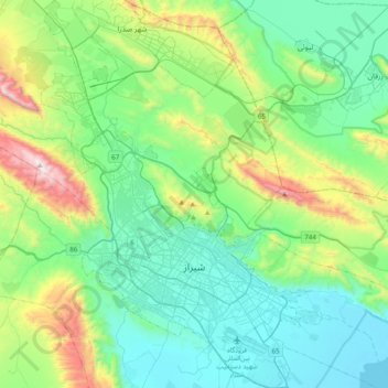
Nombre: Mapa topográfico Shiraz, altitud, relieve.
Altitud media: 1.785 m
Altitud mínima: 1.459 m
Altitud máxima: 2.877 m
Shiraz's climate has distinct seasons, and is overall classed as a cold semi-arid climate (Köppen climate classification BSk), though it is only a little short of a hot semi-arid climate (BSh) or a hot-summer Mediterranean climate (Köppen climate classification Csa). Summers are hot, with a July average high of 37.9 °C (100.2 °F). Winters are cool, with average low temperatures below freezing in December and January. Around 300 mm (12 in) of rain falls each year, almost entirely in the winter months, though in some cases as much as this has fallen in a single month (as in January 1965 and December 2004), whilst in the year from July 1965 to June 1966 as little as 82.9 millimetres (3.3 in) fell. The wettest year has been 1955/1956 with as much as 857.2 millimetres (33.75 in), though since 1959 the highest has been around 590 millimetres (23.2 in) in each of 1995/1996 and 2004/2005. Due to Shiraz' high elevation and low latitude, the UV index is extremely high during summer which is further exacerbated by the high frequency of sunshine.
Otros mapas topográficos
Haga clic en un mapa para ver su topografía, su altitud y su relieve.
Zand
Iran > Fars Province > Shiraz County > Shiraz
Zand, zone 2, Shiraz, Shiraz Central District, Shiraz County, Fars Province, Iran
Altitud media: 1.543 m
Seraj
Iran > Fars Province > Shiraz County > Shiraz
Seraj, zone 4, Shiraz, Shiraz Central District, Shiraz County, Fars Province, Iran
Altitud media: 1.552 m
Shiraz
Iran > Fars Province > Shiraz County > Shiraz
Shiraz, Shiraz Central District, Shiraz County, Fars Province, 7134754331, Iran
Altitud media: 1.754 m