
Gracias por apoyar a este sitio ❤️
Haz una donación
Haz una donación
Mapa topográfico Vanzant
Haga clic en el mapa para ver la altitud.
Gracias por apoyar a este sitio ❤️
Haz una donación
Haz una donación
Acerca de este mapa
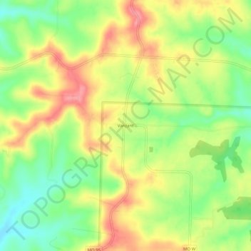
Nombre: Mapa topográfico Vanzant, altitud, relieve.
Lugar: Vanzant, Douglas County, Missouri, United States (36.94978 -92.32294 36.98978 -92.28294)
Altitud media: 352 m
Altitud mínima: 309 m
Altitud máxima: 395 m
Gracias por apoyar a este sitio ❤️
Haz una donación
Haz una donación
Otros mapas topográficos
Haga clic en un mapa para ver su topografía, su altitud y su relieve.
Ava
United States > Missouri > Douglas County
Ava is located in the southern portion of the Missouri Ozarks within the southern escarpment of the Salem Plateau. The lakes of the White River basin of northern Arkansas and southern Missouri lie to the south. The town is at the intersection of Missouri highways 5, 14 and 76. Mansfield is 13 miles to the…
Altitud media: 392 m