
Haz una donación
Mapa topográfico Mount Rose
Haga clic en el mapa para ver la altitud.
Haz una donación
Acerca de este mapa
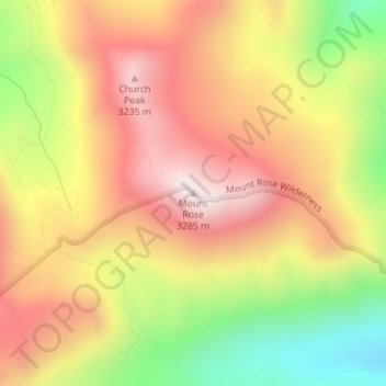
Nombre: Mapa topográfico Mount Rose, altitud, relieve.
Lugar: Mount Rose, Washoe County, Nevada, United States (39.34376 -119.91801 39.34386 -119.91791)
Altitud media: 2.919 m
Altitud mínima: 2.467 m
Altitud máxima: 3.277 m
Haz una donación
Otros mapas topográficos
Haga clic en un mapa para ver su topografía, su altitud y su relieve.
Reno
United States > Nevada > Washoe County
Reno is characterized by its diverse topography, which is shaped by its elevation and the surrounding mountain ranges. Situated at an average elevation of approximately 4,500 feet (about 1,370 meters), the city is nestled in a high desert region that features a mix of flat valleys and gently rolling hills.…
Altitud media: 1.650 m
Reno
United States > Nevada > Washoe County
Reno is just east of the Sierra Nevada on the western edge of the Great Basin at an elevation of about 4,400 feet (1,300 m) above sea level. Numerous faults exist throughout the region. Most of these are normal (vertical motion) faults associated with the uplift of the various mountain ranges, including the…
Altitud media: 1.650 m
Haz una donación
Incline Village-Crystal Bay
United States > Nevada > Washoe County > Incline Village-Crystal Bay
Altitud media: 2.173 m
Spooner Lake & Backcountry State Park
United States > Nevada > Washoe County > Incline Village-Crystal Bay
Altitud media: 2.108 m
Reno
United States > Nevada > Washoe County
Reno is just east of the Sierra Nevada, on the western edge of the Great Basin at an elevation of about 4,400 feet (1,300 m) above sea level. Numerous faults exist throughout the region. Most of these are normal (vertical motion) faults associated with the uplift of the various mountain ranges, including the…
Altitud media: 1.650 m
Haz una donación
Haz una donación
Reno
United States > Nevada > Washoe County
Reno is just east of the Sierra Nevada, on the western edge of the Great Basin at an elevation of about 4,400 feet (1,300 m) above sea level. Numerous faults exist throughout the region. Most of these are normal (vertical motion) faults associated with the extension of the earth's lithosphere and the uplift of…
Altitud media: 1.650 m
Reno
United States > Nevada > Washoe County
Reno is just east of the Sierra Nevada, on the western edge of the Great Basin at an elevation of about 4,400 feet (1,300 m) above sea level. Numerous faults exist throughout the region. Most of these are normal (vertical motion) faults associated with the uplift of the various mountain ranges, including the…
Altitud media: 1.650 m
Haz una donación
Reno
United States > Nevada > Washoe County
Reno is just east of the Sierra Nevada, on the western edge of the Great Basin at an elevation of about 4,400 feet (1,300 m) above sea level. Numerous faults exist throughout the region. Most of these are normal (vertical motion) faults associated with the extension of the earth's lithosphere and the uplift of…
Altitud media: 1.650 m
Reno
United States > Nevada > Washoe County
Reno is just east of the Sierra Nevada, on the western edge of the Great Basin at an elevation of about 4,400 feet (1,300 m) above sea level. Numerous faults exist throughout the region. Most of these are normal (vertical motion) faults associated with the extension of the earth's lithosphere and the uplift of…
Altitud media: 1.650 m
Haz una donación
Incline Village-Crystal Bay
United States > Nevada > Washoe County > Incline Village-Crystal Bay
Altitud media: 2.173 m
Reno
United States > Nevada > Washoe County
Reno is just east of the Sierra Nevada, on the western edge of the Great Basin at an elevation of about 4,400 feet (1,300 m) above sea level. Numerous faults exist throughout the region. Most of these are normal (vertical motion) faults associated with the uplift of the various mountain ranges, including the…
Altitud media: 1.650 m
Oxbow Nature Study Area
United States > Nevada > Washoe County > Reno > West Reno
Altitud media: 1.415 m
Haz una donación