
Haz una donación
Mapa topográfico Gresham
Haga clic en el mapa para ver la altitud.
Haz una donación
Gresham
Gresham is characterized by hills on its eastern border. Northeast Gresham is also hilly, especially where the city meets Troutdale toward the Columbia River. Its elevation is 325 feet (99 m). Johnson Creek, which begins at the foothills of the Cascade Mountains, runs westward through Gresham, with 23 percent of the creek's watershed running through the city.
Haz una donación
Acerca de este mapa
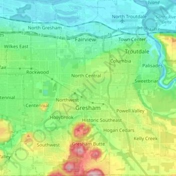
Nombre: Mapa topográfico Gresham, altitud, relieve.
Lugar: Gresham, Multnomah County, Oregon, United States (45.46094 -122.49807 45.56088 -122.36758)
Altitud media: 89 m
Altitud mínima: -2 m
Altitud máxima: 322 m
Haz una donación
Otros mapas topográficos
Haga clic en un mapa para ver su topografía, su altitud y su relieve.
Rocky Butte
United States > Oregon > Multnomah County > Portland
Rocky Butte lies in the northeast part of Portland within the city limits, in Multnomah County, part of the U. S. state of Oregon. It is one of the few smaller volcanic cones within or near Portland, along with Mount Tabor, Kelly Butte, and Powell Butte. According to the U.S. National Geodetic Survey, Rocky…
Altitud media: 67 m
Haz una donación
Governor Tom McCall Waterfront Park
United States > Oregon > Multnomah County > Portland
Altitud media: 26 m
Haz una donación
Haz una donación
Haz una donación