
Mapa topográfico Imst
Mapa interactivo
Haga clic en el mapa para ver la altitud.
Acerca de este mapa
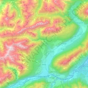
Nombre: Mapa topográfico Imst, altitud, relieve.
Lugar: Imst, Bezirk Imst, 6460, Austria (47.21095 10.53837 47.34094 10.77582)
Altitud media: 1.485 m
Altitud mínima: 666 m
Altitud máxima: 2.744 m
Imst (German: [ɪmst] ; Southern Bavarian: Imscht) is a town in the Austrian federal state of Tyrol. It lies on the River Inn in western Tyrol, some 50 kilometres (31 miles) west of Innsbruck and at an altitude of 828 metres (2,717 feet) above sea level. With a current population (2018) of 10,504, Imst is the administrative centre of Imst District.
Otros mapas topográficos
Haga clic en un mapa para ver su topografía, su altitud y su relieve.
Habichen
Austria > Bezirk Imst > Oetz
Habichen, Oetz, Bezirk Imst, 6433, Austria
Altitud media: 1.305 m
Habicher See
Austria > Bezirk Imst > Oetz > Habichen
Habicher See, Habichen, Oetz, Bezirk Imst, 6433, Austria
Altitud media: 1.148 m
Obergurgl
Austria > Bezirk Imst > Sölden
Obergurgl, Sölden, Bezirk Imst, 6456, Austria
Altitud media: 2.324 m