
Haz una donación
Mapa topográfico Bor
Haga clic en el mapa para ver la altitud.
Haz una donación
Bor
Crni Vrh is a mountain 30 km from the city center. Highest peak has an elevation of 1,043 m (3,422 ft) above sea level. It has several ski tracks anda ski lift. The main ski track is 1,100 m long and has height span of 260 m. Just 16 km from the city center there is another mountain Stol. Its highest peak has an elevation of 1,156 meters above sea level. Like nearby Veliki Krš and Mali Krš, Stol has a number of pronounced karst formations. It is also a destination for mountaineering. It has a ski lift and ski trails. Mountain Rtanj in Boljevac municipality is 50 km away from Bor.
Haz una donación
Acerca de este mapa
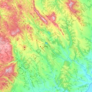
Nombre: Mapa topográfico Bor, altitud, relieve.
Altitud media: 474 m
Altitud mínima: 116 m
Altitud máxima: 1.147 m
Haz una donación
Otros mapas topográficos
Haga clic en un mapa para ver su topografía, su altitud y su relieve.
Negotin
Serbia > Central Serbia > Bor Administrative District > Negotin Municipality
Altitud media: 88 m
Boljetin
Serbia > Central Serbia > Bor Administrative District > Majdanpek Municipality
Altitud media: 388 m
Dusanovac
Serbia > Central Serbia > Bor Administrative District > Negotin Municipality
Altitud media: 91 m
Kladovo
Serbia > Central Serbia > Bor Administrative District > Kladovo Municipality
Altitud media: 89 m
Haz una donación
National Park Djerdap
Serbia > Central Serbia > Bor Administrative District
The Blederija river springs from two karstic springs at an altitude of 389 m (1,276 ft), under the Topla Bara peak. The springs are 5 m (16 ft) away from each other and one has a water temperature around 8 °C (46 °F), while the other has a constant 17 °C (63 °F). The river forms several cascades in the…
Altitud media: 420 m
Mihajlovac
Serbia > Central Serbia > Bor Administrative District > Negotin Municipality
Altitud media: 110 m
Mihajlovac
Serbia > Central Serbia > Bor Administrative District > Negotin Municipality
Altitud media: 110 m
Petrovo Selo
Serbia > Central Serbia > Bor Administrative District > Kladovo Municipality
Altitud media: 341 m
Haz una donación