
Mapa topográfico Caterham
Haga clic en el mapa para ver la altitud.
Caterham
In 1840 Caterham contained a total of 477 residents (figures taken from that census, compiled in an 1848 topographical encyclopedia) and in 1848 468 acres (189 ha) of its 2,386 acres (966 ha) were common land. Similar to today, 175 acres (71 ha) mostly steeper acres were woodland.
Acerca de este mapa
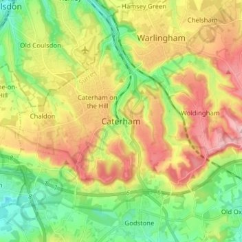
Nombre: Mapa topográfico Caterham, altitud, relieve.
Lugar: Caterham, Tandridge, Surrey, England, CR3 6QA, United Kingdom (51.24220 -0.11725 51.32220 -0.03725)
Altitud media: 157 m
Altitud mínima: 71 m
Altitud máxima: 269 m
Otros mapas topográficos
Haga clic en un mapa para ver su topografía, su altitud y su relieve.
Warlingham
United Kingdom > England > Surrey > Tandridge
Elevations vary from 110m AOD at Woldingham Road, at the southernmost point of the parish, with a gentle increase in height through the village along the main road heading to the southeast, to the highest elevation (199.6m) at Limpsfield Road.
Altitud media: 163 m