
Haz una donación
Mapa topográfico Ridgway
Haga clic en el mapa para ver la altitud.
Haz una donación
Ridgway
Ridgway is situated in the Uncompahgre Valley at an elevation of 6,985 feet (2,129 m). The town is located on the San Juan Skyway, cradled in the heart of some of the most photographed mountains in the world. The nearby San Juan Mountain Range has 14 of Colorado's 53 peaks over 14,000 feet. Among them, 14,150 feet (4,310 m) Mt. Sneffels is most prominent from Ridgway. The eponymous Mt. Ridgway, 13,468 feet (4,105 m) in height, is also nearby, 4.5 miles (7.2 km) west of Ouray. To the east of the town also lies the smaller but equally-grand Cimarron Range, with Uncompahgre Peak at 14,309 feet (4,361 m).
Haz una donación
Acerca de este mapa
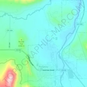
Nombre: Mapa topográfico Ridgway, altitud, relieve.
Lugar: Ridgway, Ouray County, Colorado, 81432, United States (38.14497 -107.76932 38.17818 -107.73559)
Altitud media: 2.173 m
Altitud mínima: 2.113 m
Altitud máxima: 2.445 m
Haz una donación
Otros mapas topográficos
Haga clic en un mapa para ver su topografía, su altitud y su relieve.
Ouray
United States > Colorado > Ouray County
Ouray (/ˈjʊəreɪ/ YOOR-ay) is a home rule municipality that is the county seat of Ouray County, Colorado, United States. The city population was 898 as of the 2020 census. The Ouray Post Office has the ZIP Code 81427. Located at an elevation of 7,792 feet (2,375 m), Ouray's climate, natural alpine…
Altitud media: 2.717 m
Haz una donación