Geolocalizar

Mapa topográfico Corning

Mapa interactivo

Haga clic en el mapa para ver la altitud.

Acerca de este mapa

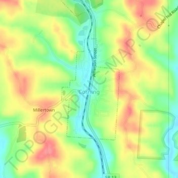
Nombre: Mapa topográfico Corning, altitud, relieve.

Lugar: Corning, Perry County, Ohio, United States (39.59524 -82.09365 39.61060 -82.08228)

Altitud media: 254 m

Altitud mínima: 217 m

Altitud máxima: 289 m

Otros mapas topográficos

Haga clic en un mapa para ver su topografía, su altitud y su relieve.

Glenford

United States > Ohio > Perry County

Glenford, Perry County, Ohio, United States

Altitud media: 273 m

Portersville

United States > Ohio > Perry County

Portersville, Perry County, Ohio, United States

Altitud media: 302 m

Shawnee

United States > Ohio > Perry County

Shawnee, Perry County, Ohio, 43782, United States

Altitud media: 278 m

New Straitsville

United States > Ohio > Perry County

New Straitsville, Perry County, Ohio, United States

Altitud media: 278 m

Mount Perry

United States > Ohio > Perry County

Mount Perry, Perry County, Ohio, 43760, United States

Altitud media: 273 m

Crooksville

United States > Ohio > Perry County

Crooksville, Perry County, Ohio, United States

Altitud media: 261 m

Glass Rock

United States > Ohio > Perry County

Glass Rock, Perry County, Ohio, 43739, United States

Altitud media: 283 m

New Lexington

United States > Ohio > Perry County

New Lexington, Perry County, Ohio, United States

Altitud media: 279 m