
Mapa topográfico Cuernavaca
Mapa interactivo
Haga clic en el mapa para ver la altitud.
Acerca de este mapa
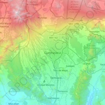
Nombre: Mapa topográfico Cuernavaca, altitud, relieve.
Lugar: Cuernavaca, Morelos, 62000, Mexico (18.76183 -99.39423 19.08183 -99.07423)
Altitud media: 1.822 m
Altitud mínima: 965 m
Altitud máxima: 3.679 m
The city is located in a tropical region, but its temperature is fairly constant at 21–26 °C (70–79 °F). It is located on the southern slope of the Sierra de Chichinautzin mountains. In the morning, warm air flows up the mountains from the valley below and in the late afternoon, cooler air flows down from the higher elevations. One ubiquitous flowering plant in the city is the bougainvillea.