
Haz una donación
Mapa topográfico Harris Mountains
Haga clic en el mapa para ver la altitud.
Haz una donación
Acerca de este mapa
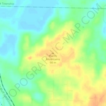
Nombre: Mapa topográfico Harris Mountains, altitud, relieve.
Altitud media: 82 m
Altitud mínima: 67 m
Altitud máxima: 100 m
Haz una donación
Otros mapas topográficos
Haga clic en un mapa para ver su topografía, su altitud y su relieve.
Pine Bluff
United States > Arkansas > Jefferson County
The city is situated in the Southeast section of the Arkansas Delta and straddles the Arkansas Timberlands region to its west. Its topography is flat with wide expanses of farmland, similar to other places in the Delta Lowlands. Pine Bluff has numerous creeks, streams, and bayous, including Bayou Bartholomew,…
Altitud media: 69 m
Haz una donación