
Mapa topográfico Camiling
Mapa interactivo
Haga clic en el mapa para ver la altitud.
Acerca de este mapa
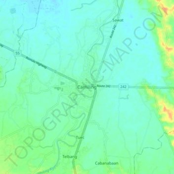
Nombre: Mapa topográfico Camiling, altitud, relieve.
Lugar: Camiling, Tarlac, Central Luzon, 2306, Philippines (15.64638 120.37468 15.72638 120.45468)
Altitud media: 19 m
Altitud mínima: 10 m
Altitud máxima: 47 m
Mostly of plain topography but some parts are hilly to mountainous in which the barangays of Papaac, Bacsay, Birbira and Cayasan, to name a few. The deeper part of the mountains can be described as a place where wild animals live, such as deer, Toddy cat (Musang), wild boar (Baboy ramo), Monitor lizard (Bayawak)