
Mapa topográfico Minot
Mapa interactivo
Haga clic en el mapa para ver la altitud.
Minot
The elevation of the river at the city center is 1,540 feet (470 m) above sea level. The valley sits 160 feet (49 m) below the surrounding plains; the elevation at the Minot International Airport on North Hill is 1,716 feet (523 m). The city has several small horseshoe-shaped oxbow lakes within its limits near the river, created by the Mouse's meandering course.
Acerca de este mapa
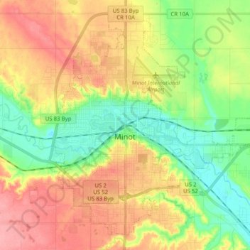
Nombre: Mapa topográfico Minot, altitud, relieve.
Lugar: Minot, Ward County, North Dakota, United States (48.19164 -101.34295 48.28304 -101.18767)
Altitud media: 510 m
Altitud mínima: 467 m
Altitud máxima: 558 m