
Mapa topográfico Chatham County
Mapa interactivo
Haga clic en el mapa para ver la altitud.
Acerca de este mapa
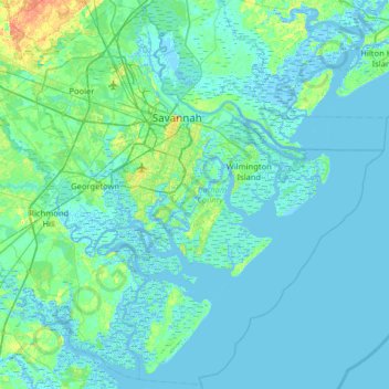
Nombre: Mapa topográfico Chatham County, altitud, relieve.
Lugar: Chatham County, Georgia, United States (31.70520 -81.39170 32.23759 -80.75143)
Altitud media: 3 m
Altitud mínima: -5 m
Altitud máxima: 28 m
Otros mapas topográficos
Haga clic en un mapa para ver su topografía, su altitud y su relieve.
Fort Pulaski
United States > Georgia > Chatham County
Fort Pulaski, Fort Perimeter Trail, Chatham County, Georgia, 31328, United States
Altitud media: 1 m
Moon River
United States > Georgia > Chatham County > Burnside View
Moon River, Burnside View, Chatham County, Georgia, 31411, United States
Altitud media: 2 m
Tybee Island
United States > Georgia > Chatham County
Tybee Island, Chatham County, Georgia, 31328, United States
Altitud media: 1 m
Savannah
United States > Georgia > Chatham County
Savannah, Chatham County, Georgia, United States
Altitud media: 4 m