
Haz una donación
Mapa topográfico Monticello
Haga clic en el mapa para ver la altitud.
Haz una donación
Monticello
Monticello is located at the base of the Abajo Mountains, or the Blue Mountains, which are part of the Manti-La Sal National Forest. The elevation of Monticello is 7,069 feet (2,155 m). From Monticello, a tree formation on the Blue Mountains can be seen, which resembles a horse's head and neck, which can be seen from any point in town.
Haz una donación
Acerca de este mapa
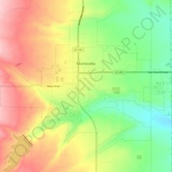
Nombre: Mapa topográfico Monticello, altitud, relieve.
Lugar: Monticello, San Juan County, Utah, United States (37.85117 -109.36881 37.88708 -109.31155)
Altitud media: 2.145 m
Altitud mínima: 2.049 m
Altitud máxima: 2.240 m
Haz una donación
Otros mapas topográficos
Haga clic en un mapa para ver su topografía, su altitud y su relieve.
Colorado Plateau
United States > Utah > San Juan County
Younger igneous rocks form spectacular topographic features. The Henry Mountains, La Sal Range, and Abajo Mountains, ranges that dominate many views in southeastern Utah, are formed about igneous rocks that were intruded in the interval from 20 to 31 million years: some igneous intrusions in these mountains…
Altitud media: 1.512 m
Haz una donación
Colorado Plateau
United States > Utah > San Juan County
Younger igneous rocks form spectacular topographic features. The Henry Mountains, La Sal Range, and Abajo Mountains, ranges that dominate many views in southeastern Utah, are formed about igneous rocks that were intruded in the interval from 20 to 31 million years: some igneous intrusions in these mountains…
Altitud media: 1.512 m