
Gracias por apoyar a este sitio ❤️
Haz una donación
Haz una donación
Mapa topográfico Centerville
Haga clic en el mapa para ver la altitud.
Gracias por apoyar a este sitio ❤️
Haz una donación
Haz una donación
Centerville
In 1913, Centerville sustained minimal damage during the Great Flood of 1913 due to its relatively high elevation. The city sits on one of the highest points in Montgomery County.
Gracias por apoyar a este sitio ❤️
Haz una donación
Haz una donación
Acerca de este mapa
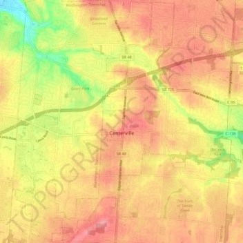
Nombre: Mapa topográfico Centerville, altitud, relieve.
Lugar: Centerville, Montgomery County, Ohio, United States (39.59062 -84.20869 39.67385 -84.09909)
Altitud media: 287 m
Altitud mínima: 226 m
Altitud máxima: 323 m
Gracias por apoyar a este sitio ❤️
Haz una donación
Haz una donación
Otros mapas topográficos
Haga clic en un mapa para ver su topografía, su altitud y su relieve.
Gracias por apoyar a este sitio ❤️
Haz una donación
Haz una donación
Gracias por apoyar a este sitio ❤️
Haz una donación
Haz una donación
Gracias por apoyar a este sitio ❤️
Haz una donación
Haz una donación