
Haz una donación
Mapa topográfico Mount Katmai
Haga clic en el mapa para ver la altitud.
Haz una donación
Mount Katmai
Mount Katmai (Russian: Катмай) is a large active stratovolcano (composite volcano) on the Alaska Peninsula in southern Alaska, located within Katmai National Park and Preserve. It is about 6.3 miles (10 km) in diameter with a central lake-filled caldera about two by three miles (3.2 by 4.8 km) in size, formed during the Novarupta eruption of 1912. The caldera rim reaches a maximum elevation of 6,716 feet (2,047 m). In 1975 the surface of the crater lake was at an elevation of about 4,220 feet (1,286 m), and the estimated elevation of the caldera floor is about 3,400 ft (1,040 m). The mountain is located in Kodiak Island Borough, very close to its border with Lake and Peninsula Borough. The volcano has caused ten known fatalities due to gas exposure.
Haz una donación
Acerca de este mapa
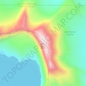
Nombre: Mapa topográfico Mount Katmai, altitud, relieve.
Lugar: Mount Katmai, Kodiak Island Borough, Alaska, United States (58.27884 -154.95338 58.27894 -154.95328)
Altitud media: 1.515 m
Altitud mínima: 1.274 m
Altitud máxima: 1.968 m
Haz una donación
Otros mapas topográficos
Haga clic en un mapa para ver su topografía, su altitud y su relieve.
Haz una donación
Haz una donación