
Mapa topográfico Lake Village
Mapa interactivo
Haga clic en el mapa para ver la altitud.
Acerca de este mapa
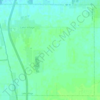
Nombre: Mapa topográfico Lake Village, altitud, relieve.
Lugar: Lake Village, Newton County, Indiana, 46349, United States (41.11556 -87.46262 41.14489 -87.42005)
Altitud media: 201 m
Altitud mínima: 196 m
Altitud máxima: 207 m
Otros mapas topográficos
Haga clic en un mapa para ver su topografía, su altitud y su relieve.
Perkins
United States > Indiana > Newton County
Perkins, Newton County, Indiana, United States
Altitud media: 211 m
Morocco
United States > Indiana > Newton County
Morocco, Newton County, Indiana, 47963, United States
Altitud media: 211 m
Goodland
United States > Indiana > Newton County > Goodland
Goodland, Newton County, Indiana, United States
Altitud media: 222 m
Iroquois River
United States > Indiana > Newton County
Iroquois River, Newton County, Indiana, 60970, United States
Altitud media: 201 m