
Haz una donación
Mapa topográfico Northill
Haga clic en el mapa para ver la altitud.
Haz una donación
Northill
Topographically, Northill stands on a slightly elevated ridge that runs north to south. The village lies on the border of the Bedfordshire and Cambridgeshire Claylands and the Bedfordshire Greensand Ridge; National Character Areas designated by Natural England. Central Bedfordshire Council has classified the local landscape around the village as within the Mid Greensand Ridge. The surrounding area is mostly arable farmland but there are significant areas of woodland to the west of the village, and parkland at Ickwell. The north and east of the parish form part of the predominantly flat, Lower Ivel Clay Valley.
Haz una donación
Acerca de este mapa
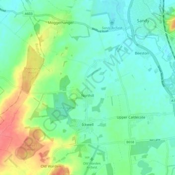
Nombre: Mapa topográfico Northill, altitud, relieve.
Lugar: Northill, Central Bedfordshire, England, United Kingdom (52.08943 -0.35975 52.12687 -0.26882)
Altitud media: 37 m
Altitud mínima: 19 m
Altitud máxima: 80 m
Haz una donación
Otros mapas topográficos
Haga clic en un mapa para ver su topografía, su altitud y su relieve.
Haz una donación
Dunstable Downs
United Kingdom > England > Central Bedfordshire > Church End
Because of its elevation, Dunstable Downs hosted a station in the shutter telegraph chain which connected the Admiralty in London to its naval ships in the port of Great Yarmouth during the years 1808 to 1814.
Altitud media: 178 m
Edgecote
United Kingdom > England > Central Bedfordshire > Caddington > Aley Green
Altitud media: 168 m
Haz una donación
Houghton Hall Park
United Kingdom > England > Central Bedfordshire > Houghton Regis
Altitud media: 134 m
Haz una donación
Haz una donación
Haz una donación
Haz una donación
Haz una donación
Totternhoe Knolls
United Kingdom > England > Central Bedfordshire > Church End > Lower End
Altitud media: 105 m
Haz una donación
Crawley Park
United Kingdom > England > Central Bedfordshire > Aspley Guise > Husborne Crawley
Altitud media: 98 m
Haz una donación