
Gracias por apoyar a este sitio ❤️
Haz una donación
Haz una donación
Mapa topográfico Detroit Lake
Haga clic en el mapa para ver la altitud.
Gracias por apoyar a este sitio ❤️
Haz una donación
Haz una donación
Detroit Lake
The water level fluctuates with snow pack, precipitation, and the water consumption of Salem, and surrounding areas. At low pool, it has a surface elevation of 1,450 feet (440 m); at the full pool season—typically May 1 to September 1—it can raise up 119 feet (36 m) to a water elevation of 1,569 feet (478 m).
Gracias por apoyar a este sitio ❤️
Haz una donación
Haz una donación
Acerca de este mapa
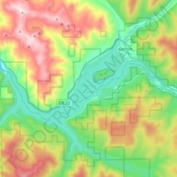
Nombre: Mapa topográfico Detroit Lake, altitud, relieve.
Altitud media: 799 m
Altitud mínima: 371 m
Altitud máxima: 1.487 m
Gracias por apoyar a este sitio ❤️
Haz una donación
Haz una donación