
Haz una donación
Mapa topográfico Glendale Heights
Haga clic en el mapa para ver la altitud.
Haz una donación
Glendale Heights
The town was originally named Glendale as it was between Glen Ellyn and Bloomingdale, but after a conflict arose with the small town of Glendale in Southern Illinois, the city decided in March 1960 to add the term Heights, in reference to its different topographies, a difference of about 100 feet (30 m) because of its location straddling the Valparaiso Morraine, thus becoming Glendale Heights.
Haz una donación
Acerca de este mapa
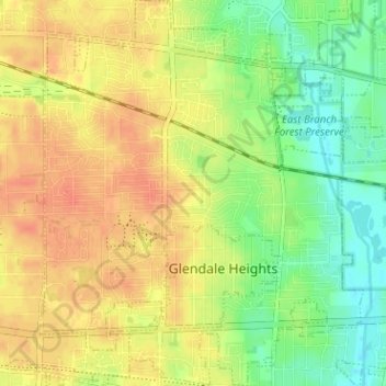
Nombre: Mapa topográfico Glendale Heights, altitud, relieve.
Altitud media: 234 m
Altitud mínima: 212 m
Altitud máxima: 251 m
Haz una donación
Otros mapas topográficos
Haga clic en un mapa para ver su topografía, su altitud y su relieve.
Elmhurst
United States > Illinois > DuPage County
Due to local topography, the town has had a tendency to flood in the past after large rainfalls; the city is currently undertaking a large effort to mitigate future flooding.
Altitud media: 207 m
Elmhurst
United States > Illinois > DuPage County
Due to local topography, the town has had a tendency to flood in the past after large rainfalls; the city is currently undertaking a large effort to mitigate future flooding.
Altitud media: 207 m
Haz una donación
Elmhurst
United States > Illinois > DuPage County
Due to local topography, the town has had a tendency to flood in the past after large rainfalls; the city is currently undertaking a large effort to mitigate future flooding.
Altitud media: 207 m