
Mapa topográfico Tholey
Mapa interactivo
Haga clic en el mapa para ver la altitud.
Acerca de este mapa
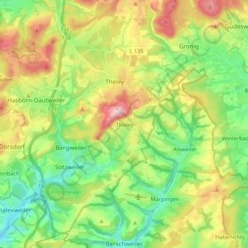
Nombre: Mapa topográfico Tholey, altitud, relieve.
Lugar: Tholey, Landkreis St. Wendel, Saarland, 66636, Deutschland (49.43667 6.91006 49.52655 7.06264)
Altitud media: 360 m
Altitud mínima: 236 m
Altitud máxima: 567 m
Otros mapas topográficos
Haga clic en un mapa para ver su topografía, su altitud y su relieve.
St. Wendel
Deutschland > Saarland > Landkreis St. Wendel
St. Wendel, Landkreis St. Wendel, Saarland, Deutschland
Altitud media: 365 m
Nohfelden
Deutschland > Saarland > Landkreis St. Wendel
Nohfelden, Landkreis St. Wendel, Saarland, 66625, Deutschland
Altitud media: 432 m