
Mapa topográfico Castlelaw
Mapa interactivo
Haga clic en el mapa para ver la altitud.
Acerca de este mapa
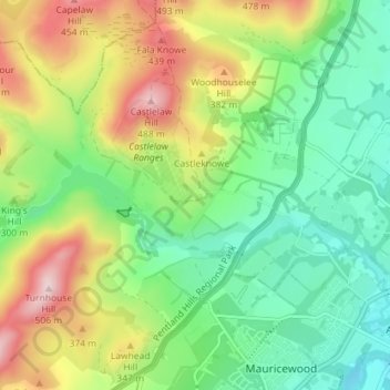
Nombre: Mapa topográfico Castlelaw, altitud, relieve.
Lugar: Castlelaw, Midlothian, Scotland, EH26 0PB, United Kingdom (55.84027 -3.25254 55.88027 -3.21254)
Altitud media: 271 m
Altitud mínima: 137 m
Altitud máxima: 501 m
Otros mapas topográficos
Haga clic en un mapa para ver su topografía, su altitud y su relieve.
Dryden Farm
United Kingdom > Scotland > Midlothian > Loanhead
Dryden Farm, Loanhead, Midlothian, Scotland, EH25 9PS, United Kingdom
Altitud media: 144 m
Bilston
United Kingdom > Scotland > Midlothian
Bilston, Midlothian, Scotland, EH25 9SH, United Kingdom
Altitud media: 169 m
Loanhead
United Kingdom > Scotland > Midlothian
Loanhead, Midlothian, Scotland, EH20 9RG, United Kingdom
Altitud media: 133 m
Rosewell
United Kingdom > Scotland > Midlothian
Rosewell, Midlothian, Scotland, EH24 9AA, United Kingdom
Altitud media: 152 m
Bonnyrigg
United Kingdom > Scotland > Midlothian
Bonnyrigg, Midlothian, Scotland, EH19 2DA, United Kingdom
Altitud media: 114 m