
Mapa topográfico A Baña
Mapa interactivo
Haga clic en el mapa para ver la altitud.
Acerca de este mapa
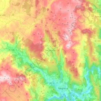
Nombre: Mapa topográfico A Baña, altitud, relieve.
Lugar: A Baña, A Barcala, A Coruña, Galicia, 15863, Spain (42.91627 -8.84152 43.00686 -8.65624)
Altitud media: 325 m
Altitud mínima: 128 m
Altitud máxima: 516 m
Vesía is a town situated near the centre of the A Baña municipality, in the A Coruña province. It is part of the parish of San Vicente, the capital of the municipality. Vesía is at an altitude of 317.6 meters above sea level, and stands at an incline of 20.89%. Vesía has a population of around 40 people, the majority of whom are between 65 and 80 years old as the area has suffered youth emigration.
Otros mapas topográficos
Haga clic en un mapa para ver su topografía, su altitud y su relieve.