
Haz una donación
Mapa topográfico Cascadia
Haga clic en el mapa para ver la altitud.
Haz una donación
Acerca de este mapa
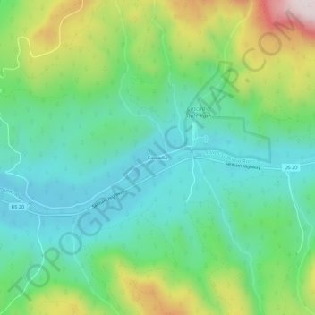
Nombre: Mapa topográfico Cascadia, altitud, relieve.
Lugar: Cascadia, Linn County, Oregon, 97329, United States (44.37729 -122.50724 44.41729 -122.46724)
Altitud media: 415 m
Altitud mínima: 235 m
Altitud máxima: 835 m
Haz una donación
Otros mapas topográficos
Haga clic en un mapa para ver su topografía, su altitud y su relieve.
Albany
United States > Oregon > Linn County
According to the United States Census Bureau, the city has a total area of 17.75 square miles (45.97 km2), of which 17.54 square miles (45.43 km2) is land and 0.21 square miles (0.54 km2) is water. Albany has 21.7 square miles (56 km2) within its urban growth boundary. Throughout the city limits and urban…
Altitud media: 71 m
Haz una donación
Santiam State Forest
United States > Oregon > Linn County
Elevations in Santiam State Forest range from 1,000 to 5,000 feet (1,500 m) above sea level. The terrain is characterized by long, steep slopes leading to broad ridge tops. Stream channels are common, and in most cases, have cut deeply into the hills. Higher elevations are rocky, especially on very steep…
Altitud media: 672 m
Haz una donación
Albany
United States > Oregon > Linn County
According to the United States Census Bureau, the city has a total area of 17.75 square miles (45.97 km2), of which 17.54 square miles (45.43 km2) is land and 0.21 square miles (0.54 km2) is water. Albany has 21.7 square miles (56 km2) within its urban growth boundary. Throughout the city limits and urban…
Altitud media: 71 m
Haz una donación
Albany
United States > Oregon > Linn County
According to the United States Census Bureau, the city has a total area of 17.75 square miles (45.97 km2), of which 17.54 square miles (45.43 km2) is land and 0.21 square miles (0.54 km2) is water. Albany has 21.7 square miles (56 km2) within its urban growth boundary. Throughout the city limits and urban…
Altitud media: 71 m