
Mapa topográfico Harare
Mapa interactivo
Haga clic en el mapa para ver la altitud.
Acerca de este mapa
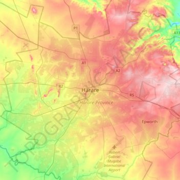
Nombre: Mapa topográfico Harare, altitud, relieve.
Lugar: Harare, Zimbabwe (-17.99177 30.88569 -17.67177 31.20569)
Altitud media: 1.470 m
Altitud mínima: 1.328 m
Altitud máxima: 1.603 m
Harare (/həˈrɑːreɪ/; formerly Salisbury /ˈsɔːlzbəri/) is the capital and most populous city of Zimbabwe. The city proper has an area of 940 km2 (371 mi2) and a population of 2.12 million in the 2012 census and an estimated 3.12 million in its metropolitan area in 2019. Situated in north-eastern Zimbabwe in the country's Mashonaland region, Harare is a metropolitan province, which also incorporates the municipalities of Chitungwiza and Epworth. The city sits on a plateau at an elevation of 1,483 metres (4,865 feet) above sea level and its climate falls into the subtropical highland category.
Otros mapas topográficos
Haga clic en un mapa para ver su topografía, su altitud y su relieve.
Manyame River
Zimbabwe > Harare > Harare > Chitungwiza
Manyame River, Chitungwiza, Harare, Zimbabwe
Altitud media: 1.400 m