
Mapa topográfico City of Utica
Mapa interactivo
Haga clic en el mapa para ver la altitud.
Acerca de este mapa
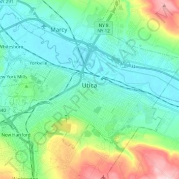
Nombre: Mapa topográfico City of Utica, altitud, relieve.
Lugar: City of Utica, Oneida County, New York, United States (43.06442 -75.29541 43.13220 -75.16103)
Altitud media: 183 m
Altitud mínima: 117 m
Altitud máxima: 389 m
The city's Mohawk name, Unundadages ("around the hill") refers to a bend in the Mohawk River that flows around the city's elevated position as seen from the Deerfield Hills in the north. The Erie Canal and Mohawk River pass through northern Utica; northwest of downtown is the Utica Marsh, a group of cattail wetlands between the Erie Canal and Mohawk River (partially in the town of Marcy) with a variety of animals, plants and birds. During the 1850s, plank roads were built through the marshland surrounding the city. Utica's suburbs have more hills and cliffs than the city. Located where the Mohawk Valley forms a wide floodplain, the city has a generally sloping, flat topography.
Otros mapas topográficos
Haga clic en un mapa para ver su topografía, su altitud y su relieve.
Town of Ava
United States > New York > Oneida County
Town of Ava, Oneida County, New York, United States
Altitud media: 420 m
Stittville
United States > New York > Oneida County > Town of Marcy
Stittville, Town of Marcy, Oneida County, New York, 13469, United States
Altitud media: 173 m
Town of Verona
United States > New York > Oneida County
Town of Verona, Oneida County, New York, United States
Altitud media: 148 m
White Lake
United States > New York > Oneida County > Town of Forestport
White Lake, Town of Forestport, Oneida County, New York, 13494, United States
Altitud media: 453 m
Fish Creek
United States > New York > Oneida County
Fish Creek, Town of Annsville, Oneida County, New York, 13401, United States
Altitud media: 133 m