
Mapa topográfico Town of North East
Mapa interactivo
Haga clic en el mapa para ver la altitud.
Acerca de este mapa
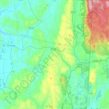
Nombre: Mapa topográfico Town of North East, altitud, relieve.
Altitud media: 267 m
Altitud mínima: 116 m
Altitud máxima: 715 m
Brace Mountain's 2,311-foot (704 m) summit, near the Connecticut state line in the northeastern corner of town, is the highest point in Dutchess County. The lowest elevation is 530 feet (160 m), along Shekomeko Creek at the Pine Plains town line.
Otros mapas topográficos
Haga clic en un mapa para ver su topografía, su altitud y su relieve.
Town of Rhinebeck
United States > New York > Dutchess County
Town of Rhinebeck, Dutchess County, New York, United States
Altitud media: 66 m
Tory Hill
United States > New York > Dutchess County > Town of Milan
Tory Hill, Town of Milan, Dutchess County, New York, United States
Altitud media: 167 m
Rhinebeck
United States > New York > Dutchess County > Rhinebeck
Rhinebeck, Town of Rhinebeck, Dutchess County, New York, United States
Altitud media: 55 m
City of Poughkeepsie
United States > New York > Dutchess County
City of Poughkeepsie, Dutchess County, New York, 12601, United States
Altitud media: 49 m