
Gracias por apoyar a este sitio ❤️
Haz una donación
Haz una donación
Mapa topográfico Smithfield
Haga clic en el mapa para ver la altitud.
Gracias por apoyar a este sitio ❤️
Haz una donación
Haz una donación
Acerca de este mapa
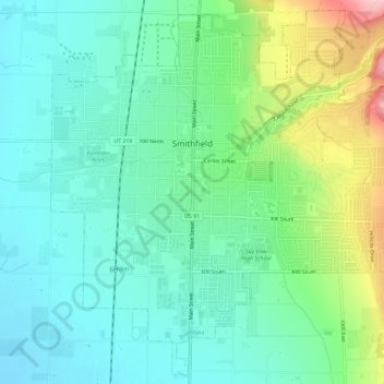
Nombre: Mapa topográfico Smithfield, altitud, relieve.
Lugar: Smithfield, Cache County, Utah, 84335, United States (41.81234 -111.85425 41.85346 -111.79611)
Altitud media: 1.404 m
Altitud mínima: 1.354 m
Altitud máxima: 1.538 m
Gracias por apoyar a este sitio ❤️
Haz una donación
Haz una donación
Otros mapas topográficos
Haga clic en un mapa para ver su topografía, su altitud y su relieve.
Logan Canyon
United States > Utah > Cache County
Logan Canyon is a canyon in the western United States in northeastern Utah, which cuts its way through the Bear River Mountains, a branch of the Wasatch Range. It is popular for both summer and winter activities, especially rock-climbing, hiking, camping, fishing, snowmobiling, and skiing, at the Beaver…
Altitud media: 1.780 m
Gracias por apoyar a este sitio ❤️
Haz una donación
Haz una donación