
Gracias por apoyar a este sitio ❤️
Haz una donación
Haz una donación
Mapa topográfico Kuşçu
Haga clic en el mapa para ver la altitud.
Gracias por apoyar a este sitio ❤️
Haz una donación
Haz una donación
Acerca de este mapa
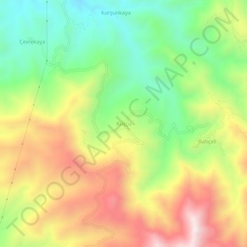
Nombre: Mapa topográfico Kuşçu, altitud, relieve.
Lugar: Kuşçu, Keban, Elazığ, Eastern Anatolia Region, Turkey (38.69982 38.72883 38.73982 38.76883)
Altitud media: 1.367 m
Altitud mínima: 996 m
Altitud máxima: 1.819 m
Gracias por apoyar a este sitio ❤️
Haz una donación
Haz una donación
Otros mapas topográficos
Haga clic en un mapa para ver su topografía, su altitud y su relieve.
Keban Dam
The Keban Dam is a combined rockfill and concrete gravity hydroelectric dam operated by the State Hydraulic Works (DSİ). The dam is 1,097 metres (3,599 ft) long and its crest is 207 metres (679 ft) above the level of the river-bed (848 metres (2,782 ft) above sea-level). Its eight water turbines are capable…
Altitud media: 844 m