
Mapa topográfico Montrose
Haga clic en el mapa para ver la altitud.
Montrose
Montrose occupies a position on the North Bank of Montrose Basin at the mouth of the River South Esk on the East Coast of Scotland, 11 miles (18 km) NNE of Arbroath, 19 miles (31 km) SW of Stonehaven, and 7.2 miles (12 km) ESE of Brechin. The town lies 62.2 miles (100 km) NNE of Edinburgh, and 373.2 miles (601 km) NNW of London. The built-up area occupies a roughly rectangular shape 2 miles (3 km) long by 0.75 miles (1 km) wide, aligned in a north–south orientation. The land is relatively flat, rising gradually to around 15m elevation to the North of the town.
Acerca de este mapa
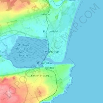
Nombre: Mapa topográfico Montrose, altitud, relieve.
Lugar: Montrose, Angus, Scotland, DD10 8QZ, United Kingdom (56.67143 -2.50815 56.75143 -2.42815)
Altitud media: 22 m
Altitud mínima: -2 m
Altitud máxima: 135 m
Otros mapas topográficos
Haga clic en un mapa para ver su topografía, su altitud y su relieve.