
Haz una donación
Mapa topográfico Incline
Haga clic en el mapa para ver la altitud.
Haz una donación
Acerca de este mapa
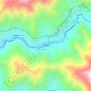
Nombre: Mapa topográfico Incline, altitud, relieve.
Lugar: Incline, Mariposa County, California, United States (37.64046 -119.87261 37.68046 -119.83261)
Altitud media: 795 m
Altitud mínima: 439 m
Altitud máxima: 1.473 m
Haz una donación
Otros mapas topográficos
Haga clic en un mapa para ver su topografía, su altitud y su relieve.
Yosemite Valley
United States > California > Mariposa County > Yosemite Village
Altitud media: 2.016 m
Echo Valley
United States > California > Mariposa County
Echo Valley is a valley in Yosemite National Park, at an elevation of 7,021 feet (2,140 m). It is located along Echo Creek, about 3 miles (5 km) west of Merced Lake, at 37°44′38″N 119°26′03″W / 37.7438°N 119.4343°W / 37.7438; -119.4343. It is bounded on the south by the Merced River.
Altitud media: 2.333 m
Haz una donación
Yosemite Valley
United States > California > Mariposa County > Yosemite Village
Altitud media: 2.012 m
Yosemite Valley
United States > California > Mariposa County > Yosemite Village
Altitud media: 2.016 m