
Haz una donación
Mapa topográfico Fairview
Haga clic en el mapa para ver la altitud.
Haz una donación
Acerca de este mapa
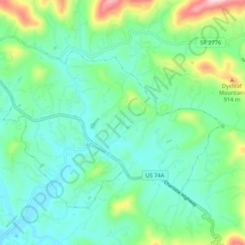
Nombre: Mapa topográfico Fairview, altitud, relieve.
Altitud media: 742 m
Altitud mínima: 655 m
Altitud máxima: 1.014 m
Haz una donación
Otros mapas topográficos
Haga clic en un mapa para ver su topografía, su altitud y su relieve.
Haw Creek Park
United States > North Carolina > Buncombe County > Asheville > Dogwood Grove
Altitud media: 666 m
Haz una donación
Haz una donación
Haz una donación
Haz una donación
Haz una donación
Royal Pines
United States > North Carolina > Buncombe County > Asheville
Royal Pines is located in southern Buncombe County at 35°28′39″N 82°30′35″W / 35.47750°N 82.50972°W / 35.47750; -82.50972 (35.477386, -82.509833). It is bordered to the west by U.S. Route 25A and the city limits of Asheville, and to the northeast by Mills Gap Road. Brown Mountain, with an…
Altitud media: 700 m
Haz una donación
Aston Park
United States > North Carolina > Buncombe County > Asheville > River Arts District
Altitud media: 641 m
Haz una donación