
Gracias por apoyar a este sitio ❤️
Haz una donación
Haz una donación
Mapa topográfico Potter Valley
Haga clic en el mapa para ver la altitud.
Gracias por apoyar a este sitio ❤️
Haz una donación
Haz una donación
Potter Valley
Potter Valley is a census-designated place in Mendocino County, California, United States. It is located 18 miles (29 km) north-northeast of Ukiah, at an elevation of 948 feet (289 m) at the headwaters of the East Fork Russian River. The CDP population was 665 at the 2020 census.
Gracias por apoyar a este sitio ❤️
Haz una donación
Haz una donación
Acerca de este mapa
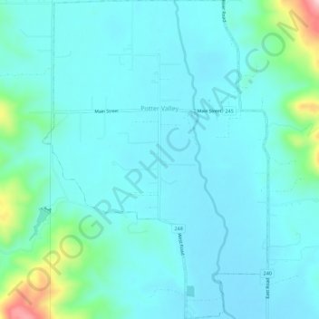
Nombre: Mapa topográfico Potter Valley, altitud, relieve.
Lugar: Potter Valley, Mendocino County, California, United States (39.29397 -123.13185 39.33655 -123.09428)
Altitud media: 317 m
Altitud mínima: 275 m
Altitud máxima: 563 m
Gracias por apoyar a este sitio ❤️
Haz una donación
Haz una donación