
Mapa topográfico Lake City
Mapa interactivo
Haga clic en el mapa para ver la altitud.
Acerca de este mapa
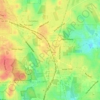
Nombre: Mapa topográfico Lake City, altitud, relieve.
Lugar: Lake City, Clayton County, Georgia, United States (33.59648 -84.36292 33.61659 -84.31865)
Altitud media: 287 m
Altitud mínima: 253 m
Altitud máxima: 317 m
Otros mapas topográficos
Haga clic en un mapa para ver su topografía, su altitud y su relieve.
Conley
United States > Georgia > Clayton County
Conley, Clayton County, Georgia, 30288, United States
Altitud media: 270 m
Bonanza
United States > Georgia > Clayton County
Bonanza, Clayton County, Georgia, 30250, United States
Altitud media: 272 m
Morrow
United States > Georgia > Clayton County
Morrow, Clayton County, Georgia, 30260, United States
Altitud media: 276 m
Mountain View
United States > Georgia > Clayton County > Coxs Crossing
Mountain View, Oak Forest, Coxs Crossing, Clayton County, Georgia, 30321, United States
Altitud media: 288 m
Irondale
United States > Georgia > Clayton County
Irondale, Clayton County, Georgia, 30238, United States
Altitud media: 269 m
Forest Park
United States > Georgia > Clayton County
Forest Park, Clayton County, Georgia, 30297, United States
Altitud media: 283 m
Lovejoy
United States > Georgia > Clayton County
Lovejoy, Clayton County, Georgia, United States
Altitud media: 275 m
Forest Park
United States > Georgia > Clayton County > Forest Park
Forest Park, Clayton County, Georgia, 30297, United States
Altitud media: 283 m
Jonesboro
United States > Georgia > Clayton County
Jonesboro, Clayton County, Georgia, United States
Altitud media: 269 m