
Mapa topográfico Kosjerić (town)
Mapa interactivo
Haga clic en el mapa para ver la altitud.
Kosjerić (town)
Kosjeríć (Serbian Cyrillic: Косјерић, pronounced [kɔsjɛ̌rit͡ɕ]) is a town and municipality located in the Zlatibor District of western Serbia. The municipality has a population of 12,090 inhabitants, but the town itself has 3,992. The municipality's area is 359 square kilometres (139 sq mi), with 26 villages mostly placed in the river valleys, though there are also some settlements in the mountains at altitudes of more than 1,000 metres (3,300 feet).
Acerca de este mapa
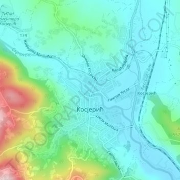
Nombre: Mapa topográfico Kosjerić (town), altitud, relieve.
Altitud media: 465 m
Altitud mínima: 398 m
Altitud máxima: 695 m