
Mapa topográfico Brasília
Mapa interactivo
Haga clic en el mapa para ver la altitud.
Acerca de este mapa
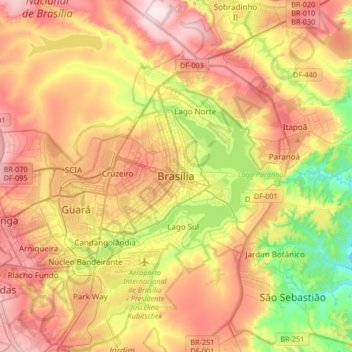
Nombre: Mapa topográfico Brasília, altitud, relieve.
Altitud media: 1.084 m
Altitud mínima: 865 m
Altitud máxima: 1.304 m
The city sits at an elevation of 1,000 metres (3,300 ft) and more, high on the Brazilian Highlands in the country's center-western region. Paranoá Lake, a large artificial lake, was built to increase the amount of water available and to maintain the region's humidity. It has a marina, and hosts wakeboarders and windsurfers. Diving can also be practiced and one of the main attractions is Vila Amaury, an old village submerged in the lake. This is where the first construction workers of Brasilia used to live.
Otros mapas topográficos
Haga clic en un mapa para ver su topografía, su altitud y su relieve.
Lago Sul
Brazil > Federal District > Região Integrada de Desenvolvimento do Distrito Federal e Entorno
Lago Sul, Região Geográfica Imediata do Distrito Federal, Região Integrada de Desenvolvimento do Distrito Federal e Entorno, Região Geográfica Intermediária do Distrito Federal, Federal District, Central-West Region, Brazil
Altitud media: 1.076 m
Ceilândia
Brazil > Federal District > Região Integrada de Desenvolvimento do Distrito Federal e Entorno
Ceilândia, Região Geográfica Imediata do Distrito Federal, Região Integrada de Desenvolvimento do Distrito Federal e Entorno, Região Geográfica Intermediária do Distrito Federal, Federal District, Central-West Region, Brazil
Altitud media: 1.143 m